Monday, October 31, 2016

Alligator-Pungo Canal

During the night, the wind on the Alligator river had stayed out of the South, keeping us extremely well sheltered.  But about 6:30 am, it turned around to NNE, which is completely unprotected.  It was amazing how fast the waves started to build, and by 7:30 there were 1 ft waves.  This made anchor retrieval that much more fun, as we had deployed an anchor trip line and float (for the first time) and I had no idea of the proper way to retrieve it.  But the Alligator river is notorious for logs and snags, so I felt it was time to learn!  Better that than having to abandon a snagged anchor!

Every time we got within reach of the float, there wasn't enough slack in the trip line to get it aboard, and when we got farther up on the anchor to provide that slack, the float sailed off to the side, out of reach!  In the end, the anchor came up easily without needing the trip line, and I just hauled it back in, so I still have no idea of the proper technique!

Once on our way, we quickly entered the 26 mile lomg Alligator-Pungo canal, connecting the two rivers.  It's a seties of narrow, arrow-straight segments that go on for miles and miles.
Alligator-Pungo Canal
We has the wind and current with us, so we flew along at 6.6 kts the entire way. Fortunately, we did not encounter any tugs with giant barges along the way!

Once on the Pungo river, we were able to motor sail with the jib for a while, before reaching our day's destination of Belhaven, NC (Mile Marker 135), where we anchored for the night.

Tomorrow: Oriental, NC


Coinjock to Alligator River

Sunday, Oct 30, we were up bright and early at 6 am, and on our way by 7:30.  Lee and Kathy helped us cast off our lines, and we headed down the river.

Today's challenge would be crossing the unpredictable Abelmarle Sound.  If wind and tide are wrong, it can be pretty rough.  The forecast was callinf for 3-4 kt southerly winds and light chop.  What we actually got was 10-14 kt winds  and 1 - 2 ft waves!  It made for a bumpy and wet ride at first, but as we approached the southern side it calmed down considerably.

Then, as we were leaving the Sound and entering the Alligator River, we had that quintessentially ICW experience: we ran aground.

I made the typical first-timer mistake of following the "magenta line" (its how the ICW is marked on the charts) instead of watching the other boats and the local marks.  We draw 4 1/2 feet, and our depth sounder alarm goes off at 6 feet.  This typically gives me only seconds of warning, and this time was no exception.  We hit at 5 kts and stopped hard.  Full reverse wouldn't budge us.  So, I put the rudder over hard, and used the prop wash against it to spin us on our stubby shoal-draft keel.  This worked, and I was then able to use forward to get us off and find some deeper water.  It was (literally) touch and go for a while, as we "bump, bump, bumped" along over the uneven bottom.  At one point, we fetched up hard against another ridge, and had to pivot again to get around it.

I later realized that we were lucky.  We were just past high tide, and had we failed to get off, would have been stranded there until the next high tide!

Other than that, we had a great day.  Even got in some motor sailing with the jib on the Alligator River (we looked and looked, but no Alligators ;) ).  Anchored in a nice cove at the southern end of the river.
Sunset on the Alligator River

Pump 1, Phone 0

Saturday, while we waited for the new raw water pump to arrive, I did an oil change while Joan performed functional testing on our horizontal deployment system.

The new pump arrived as promised, and I got right to work on it.  Before long, it was installed and tested.  Perfect!  Things were finally looking up!


So, we were all set to be on our way again Sunday.  That evening, we got together with new friands Lee and Kathy aboard their Passport 40 "Imagine" for sundowners and cards.  We had a great time.

Then, as we were climbing off their boat in the dark, I heard "bloop" and "Oh Ed, my phone!"  Joan's phone had slipped in her hand and gone overboard!  It now sleeps with the fishes. So, for the moment, we're short of comms.  Joan can still get her e-mail when we have WiFi, but no texts until we get the phone replaced. :(

Friday, October 28, 2016

The "Adventure" Continues

Well, we've had another "Adventure".  I mean, how much trouble can we get in tied up to the dock? 

As it turns out, enough! :(

This morning, our prevoius traveling companions on s/v Whisper pulled in behind us to get fuel and a pumpout.  Last night, we were aimed into the current, but this morning, the tides had reversed the current,  so it was behind us.  When Whisper went to leave, they pulled the boat far enough behind us to seemingly give them plenty of room, but none of us took into account the 2 knot current coming from behind them. They got the bow out, but then the current grabbed them and swept them right into us. They made a glancing contact with Dolce Vita's starboard stern corner.  Even then, it might not have been bad at all, were it not for the boarding ladder bracket they have that stuck out at just the wrong place.  It splintered Dolce Vita's teak toe rail and took a chunk out of the fiberglass.  Fortunately, the hull integrity was not comprimised, and the solar panel mounting was still relatively intact.
Dolce Vita's Damaged Stern

Whisper's Damaged Ladder Mount
So, we exchanged insurance information, and now I've got to go through the process of filing a claim.

Two Steps Forward, One Step Back

Thursday morning dawned with marvelous colors in the partially cloudy sky over Blackwater Creek.
Dawn Over Blackwater Creek, VA
We were just 4 miles from the VA/NC border, and planned to push all the way to Broad Creek NC, at the edge of the Abermarle Sound, before anchoring for the night, a total of about 30 Nautical Miles.

Coinjock Marina was on our way, but was only 20 NM away, so we elected to only stop there long enough for fuel, water and a pumpout, and then move on.  When we got there, s/v Whisper, one of the boats from our previous day's "convoy",  had decided to stay to wait the passage of a small front, while s/v Satisfaction, from our preious night's anchorage was continuing on.  We breifly considered staying, but in the end wanted to get more miles under the keel before we quit for the day, so we left.

Checking the weather along the way, we realized that the wind would come around to ENE tonight, and Broad Creek would offer little protection in that direction, so we scoped out a better anchorage a little closer than Broad Creek.  But before we even got there, we got a radio call from s/v Satisfaction, saying that they were anchored just ahead, and that there was plenty of depth and lots of room, and why don't we come over?  It would make for a shorter day's travel, but would give me time to do a needed oil change So we did.

As we were backing down on the anchor to set it, I happened to notice our bilge pump (which rarely runs) come on, and then, two minutes later, it came on again!  This definitely warranted investigation!

In the engine compartment, I found water dripping all along one side of the engine,  I quickly tracked this to the raw water pump, which had lost a seal and destroyed its bearing!  The little cage that normally holds the ball bearings was completely empty, and hanging out of the pump.  It's amazing that it was still pumping cooling water!
Destroyed Bearing
Fortunately, we have BoatUS unlimited towing, so we contacted TowBoatUS and requested a tow back to Coinjock Marina, a distance of about 5 NM.  The tow operator said he would be there in about an hour.  I also contacted Moyer Marine, the pump manufacturer, to ship us a replacement pump.

An hour and a half later, the tow operator called back to explain that the tow boat had broken down on the way to us, and had to be towed back itself!  But he wasn't going to leave us out there. He, and a couple of friends, were going to  launch a "family" boat to come get us, and be there in about 2 hours!  This put it well after dark, but he said they run all hours, day and night.

So, a few hours later, these three southern gentlemen show up in a 19 ft Carolina Skiff, which is a flat-bottomed fishing boat!  They rigged a hip-tow on our starboard side because the marina was holding us a 50' space on the bulkhead, and this would allow then to dock us there on our port side.

The trip back in the moonless, cloudy dark was eerie.  I had to help steer our joined craft while looking at the chartplotter to try and keep us in the center of the narrow channel, while the experienced locals relied on their extensive knowledge of every stump and shoal along the way. Sometimes the two boat's captain's had opposing ideas about which way to turn, and a zig-zagging sort of tug-of-war would ensue.  And the approach to the traffic bridge as we re-entered the Carolina Cut canal was a real high anxiety moment!

Back at the marina, they turned us upstream into the canal's significant current, and jockied us around until we were just outboard of our space on the bulkhead and just matching the current, so we "hovered" in place.  Then, with great finesse, they slowly approached the bulkhead, effectively moving the boat sideways and plugging us into our slot neat as can be!  Quite a nice feat of seamanship!

So here we sit, back in Coinjock.  The replacement pump will get shipped tomorrow, overnight, to Elizabeth City, which is the nearest location that can accept a Saturday UPS delivery.  One of the marina employees lives in Elizabeth City, and said he can pick it up on the way in to work.  Hopefully, we can be back on our way on Sunday.

Like I tell people, it's an adventure.  Of course they don't realize that the definition of an adventure is:
   Somebody Else,
   Having Trouble,
   Far Away!

Wednesday, October 26, 2016

Virginia Cut

Today we finally entered "The Ditch" as the ICW is affectionately known.  It feels like our adventure has really begun. It's been unlike anything we've done before!

First, the transit out of Hampton Roads into the Elizabeth River brought us into one of the busiest places I've ever seen.  Between the Naval Station Norfolk, with all it's military vessels, and the gigantic shipping terminals and shipyards, the scale and quantity of the machinery was overwhelming!
Naval Station

Massive Shipping Terminals
And intimidating. One set of cranes put me to mind of a child's nightmare monster.
Two Armed Hulking Monster
Further down, we were presented with a real treat, a view of the WWII Battleship Wisconsin
Look at Those Big Guns!

And then, there we were, at Hospital Point, the "Mile Marker Zero" of the ICW.
Hospital Point Anchorage
A railroad lift bridge started off what will be a long list of bridges to pass.
Are You Sure We'll Fit?
Our first bridge challenge was making the next opening of the Gilmerton Bridge.  We were minutes away and it was already opening!  As the bridge fully opened and the waiting boats started through, I called the bridge operator, gave her our position, and asked if we would make it. She replied "If you step it up a little, I'll hold it for you".  So we pushed our trusty Atomic-4 up to 2900 RPM, close to wide-open-throttle, and squeeked through after the end of the pack.
Following The Pack Through Gilmerton
Our next challenge was the Great Bridge Lock.  Although we got there with plenty of time, and there was plenty of room, I disgraced us badly by blowing my first two attempts to get tied up to the starboard wall (we prop-walk to port in reverse).  By the third attempt, the lockmaster was getting quite upset with us!  After all that drama, the actual locking operation was quite sedate and almost unnoticeable.
Great Bridge Lock
We decided to press on after Great Bridge, especially since we noticed that, at 1:00, the free dock was already full.

So after seemingly endless miles of drowned trees and marshes, we set anchor in a little side creek in the middle of nowhere in the marshes, and only about 4 NM from the North Carolina border.
Traveling In Convoy
We grilled a fabulous steak dinner to celebrate.

Total travel for the day was 39 NM (45 Statute Miles) , anchored at mile marker 30.  All in all, a great day.

Tuesday, October 25, 2016

Go (South) West

Well, we finally got out of Cape Charles.  But it was an ordeal.

We were up before dawn, and cast off by first light.  We planned, as was becoming our habit, to have coffee and breakfast underway.

Bad move.

As soon as we cleared the harbor's breakwater, we found the wind blowing 15-20 out of the north and 3-4 ft waves and chop, being opposed by the incoming tide.  As our course to Hampton was roughly SW, this put the waves on our stern quarter, which produced violent rolling.  So although it was finally a North wind we could potentially sail on, it was too dangerous to send anybody forward to the mast to work the halyards,  so we still ended up motoring.

Short But Rough

Joan tried to go below to get coffee, but was being flung around the cabin repeatedly.  There was no way she could pour coffee, so she came back up into the cockpit.  I had the wheel to hang on to, but she was still getting pretty tossed around.  I suggested she sit in the cockpit floor, as the rolling would be less there, and there would be some warmth from the engine below.  It must have worked, because she pulled her hat down and fell asleep.  I had to keep prodding her every so often to make sure she was alive! ;)
Dead in the Water
Once we got into the Hampton Roads (a confluence of several rivers at the mouth of the Chesapeake Bay), the waves subsided, and we were able to finally have some coffee and a light brunch.

Up the Hampton river, we docked at the Hampton Public Piers before 1:00 pm.  They have great rates ($1.25/ft for BoatUS members) and are right in town.  There we ended up right next to a Pearson 365, crewed by a cruising couple, Steve & Judy,  who have been full-time liveaboards for 14 years!  We had them over for sundowners and snacks, and talked for a long time.  One of the nicest things about this trip is the great people you meet at every stop.
Ed, Steve, Judy
We even had a few hours before sundown to hike around town, get a few errands done, treat ourselves to dinner out, and even go for a carousel ride!

This point in our trip marks a sort of milestone, as it's the farthest South we've ever been with Dolce Vita before.  Tomorrow, we launch into truly new territory!  Our plan is to go to Great Bridge VA, go through the lock, and tie up at one of the two free docks there.

Monday, October 24, 2016

Moving Again (Sort of...)

Well, we finally got the boat on the move again.  Except that it was only a couple of hundred yards to the fuel dock!

We were all set to go this morning, honest! Set the alarm to 6 am and got up ready to go.

But it was still blowing hard with whitecaps in the harbor, despite the forcast calling for things to calm down to 10-15.  After watching three other boats depart and struggle their way out of the harbor, we decided we really didn't want to bash into that stuff  for 6 or 7 hours.  The wind at Cape Charles was W, but the reported wind down at the Bay Bridge-Tunnel was SW, so it would have stayed on our nose the whole way.

Our new friends on Promise went North, and they had a good sail once they were far enough out of Cape Charles and could head North.

We stayed around, and worked on boat projects; Joan making curtains, and me repairing some velcro on a cushion back.

Later in the afternoon, the weather quickly changed and became almost dead calm, with a very light breeze out of the NNE!  The Marina became glassy smooth, and we decided to take this opportunity to get out of our slip and head to the fuel dock for gas, water, and a pump-out.  Afterwards, with the harbormaster's permission, we tied-up on one of the dock's T-Heads instead of going back to our slip.  This way, even if its blowing hard tomorrow morning, it will be easier to cast off.

So, we're all ready to resume our travels in the morning.

Saturday, October 22, 2016

A Stay in Cape Charles

Well, here it is, Saturday, and we're still in Cape Charles, and likely to be here Sunday too.
 Friday, we got a ride to the Food Lion, courtesy of the marina,  and did some reprovisioning.  The driver waited for us while we shopped! Life really is different in a small town.  It worked out well because the front and its rain were later arriving than originally predicted.

We've met several other couples on sailboats: Mike & Lisa on the 50' Hunter "Promise", Melissa & Anne on the Catalina 445 "Moondance", and Wes and Sheryl on the Wauquiez Hood 38 "Merlin", all here waiting out the front's passage.  We did sundowners with Mike & Lisa on Promise and watched the front roll in.
The Front Arrives late Friday Afternoon
We originally chose Cape Charles as a layover while the cold front and it's gale-force winds passed.  Turned out that wasn't such a good choice.  Because of the orientation of the town harbor, and their incomplete breakwater, any wind with a westerly component makes it very bouncy here in the marina.  For the last day it's been blowing NW 15-20, with gusts much higher, and a 1 foot swell plus chop in the marina!  We slept ok, but our slip is in the lee of the resturant, and isn't getting as much wind as the others, who were up most of the night tending lines.

The floating docks here make things interesting in these conditions.  Trying to walk on them feels like you're coming back from a long and successful happy hour!  And Dolce Vita is constantly straining at her lines.

Today we spent most of the time in town, getting some copies made of ICW updates from Melissa, and visiting the many shops and galleries.  The town library is located in a building that used to be a bank.  The Local History room is housed in the vault!
The History is Secure!
And Watson's family Hardware Store is like stepping back in time 50 or 60 years!
Another Era
We finished off the afternoon with a meal at Kelly's Irish Pub.

This evening, after dark, I suddenly saw nav lights flying down the main channel in the harbor!  At first I thought one of the boats in the marina had had enough of bouncing, and was trying to get back into the sheltered lagoon by the fuel dock.  With these conditions, this would have been a crazy thing to attempt in the daylight, let alone in the dark!  But then the lights abruptly turned and headed back.  This repeated another time, and I realized that this was a new boat arriving and trying to get onto the T head of one of the docks!  I and several others raced to that dock to find a 60' Beneteau Oceanus struggling mightly to get a line on the docks. Despite the wind and current, the captain was maintaining an amazing amount of control, but the wind kept grabbing his bow and flipping it outward at the last second, despite his bow thruster.  Eventually, he backed his stern up to the dock and we got several lines over and pulled him in without incident.  Our excitement for the evening!

Tomorrow, the wind is supposed to come around to the West, still blowing 15-20.  This will be blowing directly into the Harbor.  Just getting out of the slip without damaging the boat would be difficult, so we're probably going to hang here another day.

Thursday, October 20, 2016

Sandy Point, VA to Cape Charles

After a delightful evening of perfect weather as we sat at anchor in Sandy Point VA, we got up early enough to be underway by 8:15.  Cape Charles was our destination, about 40 nm away.  Before leaving, I topped off the oil and checked the gas tank. We had about 12 gallons left, which, at a gallon or so an hour, should be plenty to get to Cape Charles.

Again, we ate breakfast underway.  We're really getting to enjoy that.

With winds predicted out of the SW, and our course being about SSE, I thought we'd be able to get in some sailing today, or at least motorsailing.  Alas, it was not to be.  The wind ended up right on our nose again, so we motored.

The southern Bay is big water, and begins to look and feel like the ocean.  Increasing swells rolled out of the South, again building to 1 to two feet.  While the tide was in our favor, we were able to maintain 5 1/2 kts, but once it turned, we dropped to less than 4 kts!

When we were within about 4 miles of our turn into the Cape Charles entrance, a windshift suddenly made motorsailing possible.  It wasn't worth it to put up the main for that short distance, so we just unfurled the jib instead.  This gave us a boost to 4 1/2 to 5 kts.  Finally, sailing (sort of). Hurrah!
Motorsailing on Jib

But when ithe wind suddenly shifted back to its former heading, I was unwilling to drop sail so soon, so we fell off until the jib was drawing good again.  This brought us further West than we wanted to be, but we were sailing!

By the time we were ready to make our turn towards the entrance channel, the wind had piped up to 12 or 13 kts, making it fairly difficult to furl the jib, so I got a good workout.  But just as I was about to put the last turn on the furler, the engine faltered a couple of times and quit!  I had to quickly put the jib back out to give us some control and headway while I dealt with the problem.

I was pretty sure I already knew what it was, and a quick dip of the gas tank confirmed it.  We were out of fuel!  Apparently, with the engine working so hard against the wind and current, our fuel consumption rate had been much higher than I had been using to estimate our range.

Fortunately, we carry three 5-gallon jugs of fuel stored on the sidedecks, so I got one of them and emptied it into the tank. Because we have a gas engine, not a diesel, there is no difficult re-priming  of the fuel system required when you run out.  Problem solved, and we were on our way again.
Refueling Underway

Got into Cape Charles Town Harbor just 15 min before sunset, and tied up to their substantial floating docks.  There, we mat Mike and Lisa of the s/v Promise, a 50' Hunter that we had seen out sailing earlier.  They're on a two week trip around the Bay, and had also decided to hide out in Cape Charles for a couple of days to let the weather front pass as we were doing.

So, Gin & tonics for the ladies, and Rum shots for the men. Life is good on the water.

Wednesday, October 19, 2016

An Easy Day

Although we wanted to leave Solomons early this morning in order to take full advantage of the tide, we realized that, if we didn't get a pumpout today, our next opportunity would not be for two days, and that would bring us to four days since a pumpout.

Our holding tank is barely good for three days!

As a result we got to sleep a little later, as the pumpout at Zanheizer's doesn't open until 8am.  And so, at 8:30, with holding tank empty and water tanks full, we set out for Sandy Point VA, on the shores of the greater Wicomico River.  We would still get a lot of boost from the tide, but it would turn against us about 1:30 in the afternoon while we would still be partway across the mouth of the Potomac River. 

Those who have sailed this area know that it can be particularly rough at times.

Things started out pretty smooth, and we got a big boost from the ebb tide as we came out of Solomons.  It was actually showing 6.7 kts speed-over-ground (SOG), but every time I tried to snap a picture, it changed!
Smooth Motoring
Great Speed Over Ground
Since we had gotten underway without breakfast, just coffee, Joan took this opportunity to whip up a scrumptous breakfast wrap.


Once on the Bay, we saw an increasing procession of southbound sailboats, all under power as we were.  I suspect many, if not all of them, were bound for the ICW too.  Most were larger than us, and able to motor faster.  And all of them were further out in the Bay, probably to take better advantage of the south current in the deeper water.  We hung in closer to the shore in order to minimize the distance to the entrance to the Wicomico.

As we passed south of the Patuxent Naval Air Base, I noticed a small navy runabout visiting all the southbound boats one by one, and asking them to switch to channel 14.  Suspecting what was coming, I followed suit to 14 and listened in.  Turns out, the Navy was preparing to conduct an exercise on their target range (which encompases most of the width of the Bay!) and were requesting the boats to stay within 3/4 mile of the western shore until south of Point No Point.  So my inshore course was right, but for the wrong reason!  This was why we hadn't earned a visit from the Navy.
Point No Point Light
When southbound, Point No Point marks the beginning of the crossing of the wide mouth of the Potomac River.  We almost immediately noticed a change in the waves.  The short chop was replaced by longer, rolling swells, which Dolce Vita easily rode up and over instead of subjecting us to endless pounding.  Seems we got lucky this time!  The whole crossing was quite pleasant.  About 2/3 of the way across, the tide turned, and we noticed our speed steadily dropping until we were down to 4 kts, but the passage remained smooth.  And once we cleared Smith Point and turned towards the Wicomico, our speed improved again.
Smith Point Light
At the entrance to the Wicomico, the fish trap stakes extend annoyingly far out.  I watched another sailboat "cut the corner"  by motoring through a large gap in the line.  I was unwilling to risk this, as who knows what pieces of lost line and netting are hanging in there, waiting to snare an unwary prop!  So we went the long way round.

We pulled into Sandy Point at 4:50pm, and found three boats already there.  Within another 20 minutes, two more came in after us, and another one right before sunset.  This anchorage is large, and could hold many more boats easily, so our seven boats were widely spaced.
Loads of Room
We poured end-of-voyage drinks and watched the sun set, and then grilled up burgers for dinner.
Sunset
Our total distance for today was 42.6 nm.  That's more like it! :)  All in all, a very good day.

Tomorrow, we're going to go slightly out of the way and go SE across the bay to the town of Cape Charles, and take a slip there.  It's another 40 nm run.  We will take this opportunity to replenish some of our perishables, and perhaps wait out the bad weather that will be moving in on Friday.

Tuesday, October 18, 2016

Losing Our Cool

We managed to get to bed early enough last night that I was able to get up at 5:00 am this morning.  It was a beautiful clear night, without a hint of dawn yet in the sky.  I let Joan sleep for a few more minutes while I put on a (pre prepared) pot of coffee.  I was looking forward to being out of the Patuxent River and out on the Bay to watch the sun rise.  I love it when a plan comes together.

As I waited for the coffee, I checked the battery monitor, and was surprised by how few Amp-Hours we had burned through over the night.  As I puzzled on this too-good-to-be-true number, I caught sight of the refrigeration temperature gauges.

Instead of being at -18 deg C (0 deg F) the cold plate gauge was showing -9.4 deg C (15 deg F) and rising as I watched!  At this rate, our entire supply of frozen food would be thawing within a day!

The refrigeration compressor is located in the far aft of the port sail locker, which is jam-packed with stuff.  So, first order of business was to empty the locker.  With the deck now looking like a derelict boat, and all the rest crammed into the cabin, I lowered myself into the cavernous locker to start troubleshooting. 

My ears told me the fan was running continuously, but the compressor was "short cycling", trying to come on, then stopping for a few minutes, only to repeat the cycle.  No wonder our power consumption was so low!  This must have been going on all night! I got a meter and clip-leads to probe the diagnostic terminal on the controller  to see what kind of an error code it was producing.  But before I could probe it, the compressor fired up as normal and began cooling! 

I watched it cool all the way back to -18C, and then shut off.  Later, when the temp had risen a few degrees, in came on again as normal and cooled.

Now we had a dilemma.  The compressor was working, but for how long?  If we left Solomons, there wouldn't be any real support services along our planned stops until we got to Norfolk.  But right here in Solomons, there is no shortage of marine services, including the most excellent Zanheizers.

So, after a short discussion, we decided to call Zanheizers.  Left a message with the service department and settled in to wait.  I hope we're getting all of our bad karma out of the way at the beginning of the trip!  I mean, two failures in three days!

As we sat around waiting for a return call, Joan spotted a bald eagle landing in a nearby treetop.  Maybe this was a good omen.

Finally, we got a call.  They would be able to take a look at it today!  So we pulled the anchor and wandered down the creek to Zanheisers.  Dockmaster Terry directed us into an empty slip and helped us tie up.  And within a half hour, the tech showed up, tools and part in hand.

It turns out that this is a fairly common problem with these systems.  The electronics in the controller has circuitry to detect a stalled compressor and shut down.  Unfortunately, as they age, they tend to produce "false alarms", stopping when there really is nothing wrong.  After verifying that the compressor was ok, he replaced the control module, which was fully connectorized.  The newer version is a drop-in replacement, and has better circuitry which produces a higher "starting torque" in the compressor to avoid this problem.

So, the fix was easy, but pricy.  In a masterful understatement, the tech said, "They ain't giving these things away!"   $295 for a box the size of two packs of cigarettes.
Defective Controller, with Dime for Scale

That, plus labor, brought the whole fix to $480.  Good thing we have a contingency fund!

So, the saga continues.  Tomorrow, we'll try again to get to the Wicomico River.

Monday, October 17, 2016

To Solomons

Yesterday, we arrived at Herringtom Harbor North marina just at sunset.  This place is a HUGE marina, with 600 slips, pool, resturant, various marine businesses, and even a West Marine, all onsite! We will definitely go back in the future and spend some time looking around this place.  Weekday rates were a reasonable $2.00 a foot with an outstanding 20% discount for BoatUS members! This brought it down to a most excellent $1.60 per foot. The piers are substantial,  and the slips have full-length finger docks, allowing for the easier bow-in docking. The only thing this place doesn't have is fuel.

And they have a a sister marina, Herrington Harbor South, with another 600 slips and it does have a fuel dock.

So, this morning, by the time we topped our water tanks, slipped our lines, stopped for the included self-service pumpout, paid our bill, and stopped at H.H South for fuel, it was already 11:30!  The tide was still running in our favor, but would turn in another two hours. (lesson learned: we need to get up earlier in order to make maximum use of the tide.) The wind was still out of the South, and they were again calling for 5kts and waves 1 ft or less.  Sound familiar?  I was skeptical.

So we set out for Solomons. And it really was 5 kts and small waves!  No pounding to slow us to a crawl! At first we were doing an excellent 5.6 - 5.8 kts as the .9 kt current helped us along.  But somewhere around 2:00 pm we began slowing, eventually dropping us to 4 kts.  At this rate, I figured we'd get into Solomons between 8:00 and 9:00.

On the VHF, we heard about some sort of Naval exersize going on.  Later, saw a procession of several different military ships go by.


The long 20 nm leg from Herring Bay to Cove point always seems to take forever, but eventually we started to make the shape of the giant, mile-long LNG pier.  About that time, the first pelicans started making their appearance.  Despite their ungainly appearance, pelicans are strong and agile fliers,  the "fighter pilots" of the southern bay's skies.


In order to get an early start tomorrow,  we decided to have dinner "on the road",  so that once we were anchored in Solomons for the night, we could do our blogs and get to bed early.  Surprisingly,  once we turned into the mouth of the Patuxent, our speed went up to over 5 kts!  As a result we finished dinner (a most excellent Pork chops with apple sauce and Broccoli) just in time to anchor right before sunset!  Total distance for the day was 32.3 nm.

Tomorrow, we plan an ambitious 40 nm leg.  We will attempt to get up at 5 am pull the hook, and get going in order to make full use of the ebb tide.  Our destination will be an anchorage on the Wicomico River called Sandy Point.  If we do this right, we'll be there in the afternoon, allowing some time for chores and projects before the sun sets.

Sunday, October 16, 2016

No Pressure

Joan's always warning me she wants no pressure on this trip.  Well, this morning, she got her wish.  We started the engine getting ready to depart for Solomons Island, and the oil pressure gauge showed no pressure! 

So much for leaving early! After quickly shutting the engine off, I got out the tools and began doing some diagnostics.  A failed oil pump would be disastrous, as that would require major engine disassembly.  Fortunately, it appeared that the oil pressure was actually fine, it was just the gauge that had failed.  So I began tearing panels open to unwire and remove the troublesome gauge.
Getting at the Gauges from Behind, Inside the Cabin
 Amber graciously agreed to drive me into town to try and locate a replacement gauge.  We eventually located one that was almost an exact replacement.  A few hours later, I had it tested and installed.
Shiny New Oil Pressure Gauge
Now it was two thirty, and Solomons was still 40 nm away.  Forecast was for warm temps and light air, building to only 5 kts out of the South.  So we decided to go.  We figured that motoring at 5 kts would get us there around 10 pm which was not ideal, but doable.  It seemed better than losing a whole day.

I should have remembered the "No Pressure" rule.

Once we got out on the bay, we discovered that the wind was actually blowing 15 kts out of the South, not the promised 5!  With the long fetch out of the South, this built the chop up to 1-3 feet. In addition, NOAA Weather was reporting a "tidal anomaly" that was resulting in an extra high tide, and that tide was also running against us.  Between the wind, waves, and current, we were barely making 3 kts, sometimes less, even with the engine cranked up to a higher than normal throttle setting.  It became quickly apparent that Solomons was no longer an option. unless we wanted to pound into this unpleasant stuff all night.

As many of you probably know, that stretch of the Western shore of the Chesapeake from the West River down to Solomons is almost completely devoid of inlets of any kind.  Pretty much the only choices were either to pull into Herrington Harbor at Deale or to turn back.  So we got on the phone to Herrington Harbor North marina, and they had a slip for us.  At this point, they were only another 7 nm away, but it still took us hours to get there.  We finally pulled in to the marina around 6:30, just before sunset.  Total elapsed travel for the day was a measly 15.8 nm, and half of that was going in and out of harbors!

But that's ok, because there is No Pressure on this trip! :)

Saturday, October 15, 2016

Zero Hour, 9 AM

At long last, our departure day has finally arrived.  Stomach butterflies have been replaced with excitement!

After a mad last-minute gathering up of our very last items on Friday night. we drove to Dolce Vita and moved aboard.  Our daughter came with us to drive our car back home.

The boat was sitting low on her waterline.  I estimate we've loaded between 1000 and 1500 lbs of food and equipment.  The V-berth looks like a storage locker, as it is the only large space to store most of the bulkier items.
Loaded V Berth
Unfortunately, this means that we have to move all this stuff to the main salon every evening, and move it back every morning, as we sleep in the V-berth.  So, we moved it for the first (of many) times and went to sleep.

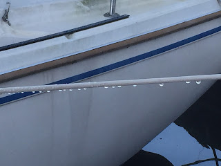
Saturday morning was lightly foggy, with a heavy dew.  The 7 am temp in the cabin was 58 degrees, which had made for nice sleeping under the blankets, but made it somewhat hard to get out!

Heavy Dew

Our friends Bill & Lisa (s/v Greater Expectations) and Jim & Faith (s/v Dreamcatcher), drove down to the dock to see us off.  It turned into a regular mini dock party!
Sendoff Party
Away from the Dock

And We're on Our Way!
There was almost no wind, so we motored.  (Good practice for the ICW!)  Later in the afternoon the wind came up to about 5, but came around to blow from the South!  Two weeks of North winds, and now that we're moving, we get South!  Oh well, at least we're moving!

Around 1, Joan asked if I was hungry.  I said a little, so she went below to rustle up something.  I was expecting a quickie snack of cheese, lunchmeat, and fruit.  I should have known better.  This is Joan we are talking about.
Lunch is Served
Today was a somewhat short day.  We went down to the Rhode River to anchor for the night, and got there by about 3 pm, covering only 28 nm for the day.  But it would have been a really long day if we had tried to go all the way to Solomons Island in one day.  This is supposed to be a fun trip, not an endurance contest.

Once into the Rhode, we called our friends Pope & Amber (s/v Echo II), who we knew were docked somewhere nearby, and are also preparing to go south shortly.  Turns out they are docked right across from where we were going to anchor, so instead we ended up tying up at their marina and having a most pleasant dinner with them.  Tomorrow, we head for Solomons.

FOLLOW ALONG WITH US

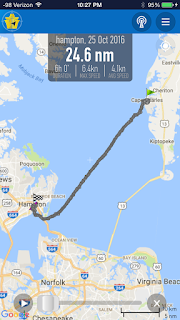
For this trip, I'm going to try and use a position-tracking app on my iPhone called "On Course", that will let folks check up on where we are and show our track for the last day or so.  The link to get to it is http://www.marinetraffic.com/en/ais/home/shipid:4130443

If you have trouble with this link, our MMSI is 338125454. Just enter it in the search box on the marinetraffic.com site.

Friday, October 14, 2016

And So, It Begins!

The new card came in today!  We're madly collecting up some last minute things and heading to the boat tonight!  Departure 9am tomorrow (Saturday). 

Thursday, October 13, 2016

Still Holding

Well, not surprisingly, the replacement card didn't come today (Thursday).  So now, assuming it comes on Friday,  the earliest we can leave is Saturday.  Going to spend the night on the boat tonight and get an early start on some minor projects tomorrow instead of just waiting around for the mail to come.

Wednesday, October 12, 2016

This Would Almost Be Funny if it Wasn't So Painful

On Tuesday, I got on the phone to the card issuer to see what was up.

Well, it seems that, as usual, financial institutions continue to live down to my expectations.  It turns out that, despite our long conversation about our situation, the service rep somehow decided that I didn't want the expedited service, and sent it in with regular priority (ie - none at all)!

So, even though I talked to him on last Thursday, the request didn't even get submitted to the outside card services company until Monday! And since Monday was a government holiday, the new card didn't go into the mail until Tuesday. 

So now, there's nothing they can do.  I'm told it will "probably" get here this week sometime.   The way I figure it, it'll be at least 3 days to get here from the west coast.  That makes our earliest likely departure now at Friday!

I just cant believe how, despite all our careful planning and prep, we're still ending up getting a late start by 2 weeks!   Arrrrgh!  Well, you know what they say:  Life happens.

And listening to all the disruption that Matthew caused in North & South Carolina, maybe its just as well if we give it more time before casting off.

At this point, we have no food in the house because we cleaned out the fridge.  But the boat is loaded up!  So this evening we drove to the boat and Joan worked her usual magic and whipped us up a wonderful stovetop chicken casarole.
Joan in Her Element