Monday, March 18, 2019

Man O War

1755 nm   N26 35.682  W077 00.433

 Our trip today was a staggering 7 miles!  In general, things are pretty close together in the Abacos, making it practical to island hop back and forth without having to plan out a route that steadily moves you in a single direction.

The trip was so brief that it was hardly worth it to get up the sails.  We rolled out the jib for a bit, but quickly had to furl it as we approached the harbour entrance.

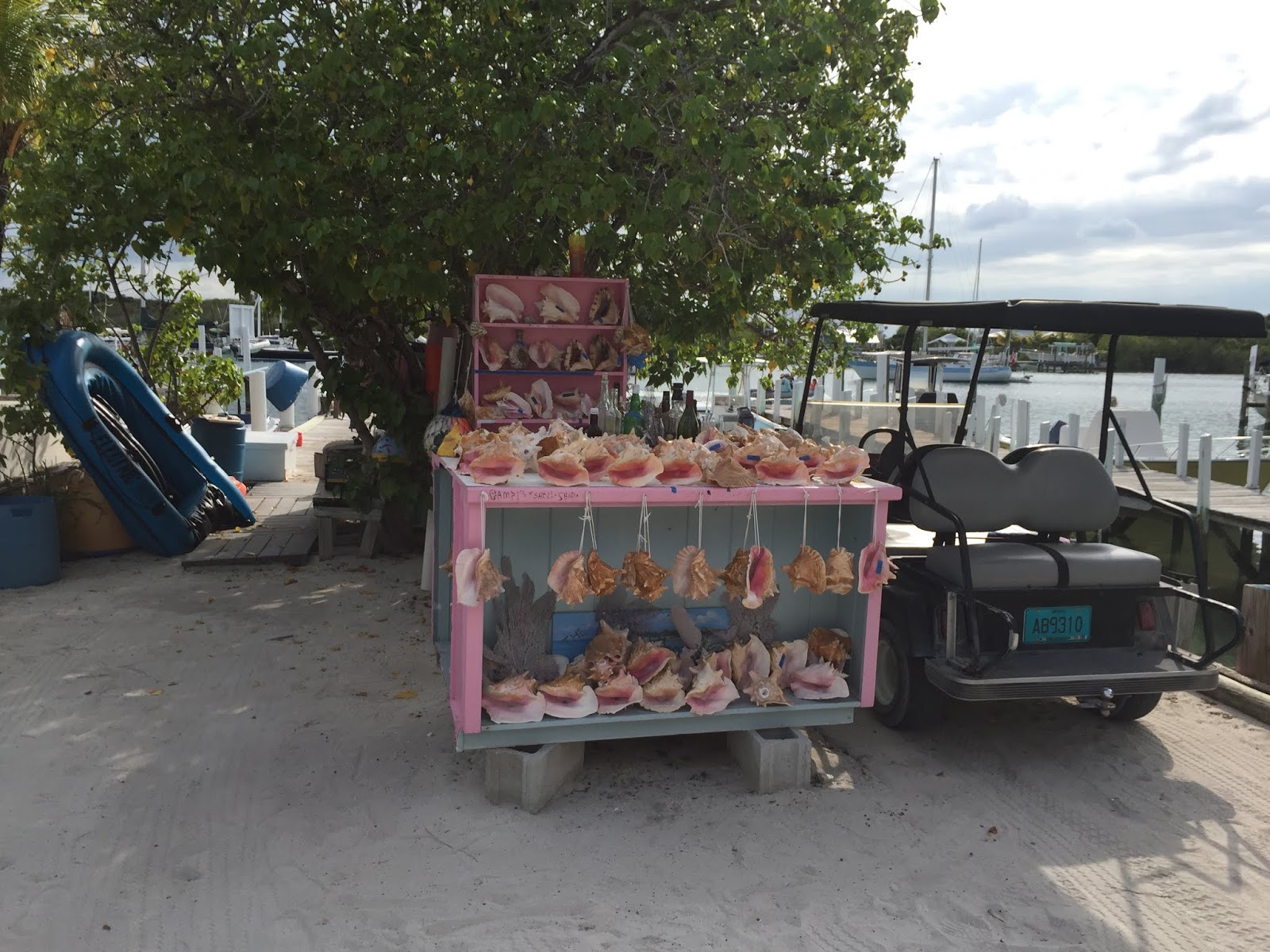
Man O War has two mooring fields, one in the north and one in the south.  We chose the north one, an that's where our friends Ron and Phoebe were.  There were several mooring balls empty, but they were extremely close together.  We picked up one, but I was unhappy with how close it let us swing to the boat behind us, less than a boat length!  I was later to discover that this close spacing is pretty typical in the Bahamas.  We found another empty mooring, right next to a motor yacht named "Christian".  The woman aboard told us that that one was empty and would be fine for our length boat, so we quickly picked it up.

On this trip, we're becoming quite adept at picking up a mooring ball.  We've adopted a technique that uses a long (40 ft) line attached at the bow and led back, outside of all the rigging, to a point amidships.  The rail is much lower to the waterline there, making it easier to grab the mooring pennant, and the helmsman can see the ball as we approach it, making it much easier to keep the boat on station next to it.  Once the line is looped through the pennant and brought back to the bow, we are securely tied in place, and its easy to get a second line through the pennant.
Moorings are REALLY Close Together at MOW!
We went ashore to the Man O War Marina, and found Ron & Phoebe.  Unfortunately, they were in the middle of an unplanned disassembly of their toilet and its plumbing, and were pressed for time because they needed to get it done and get to Marsh Harbour tomorrow to pick up their son Matt and his girlfriend.  Still, they found time to take an hour out and socialize.  We really enjoyed seeing them!
Ron and Joan
Phoebe
Man O War was a delight after Marsh Harbour.  It was extremely clean and neat, with just the right balance of quaint with a few conveniences and concessions to tourists.  It was a small but thriving community, with active businesses oriented more towards boatbuilding and fishing than tourism. The "roads" were double-wide concrete sidewalks, which were used primarily by golf carts, although you could walk to either end of the island.  And the houses and signs were brightly painted with all kinds of colors.  No pastel shades here!

Joan on "Lover's Lane"
The Main Road
The next day, the front came through and rained most of the day, keeping us on board.   Our bimini cover is getting old, and the rainwater that collects on it tends to drip through, so Joan got on her bathing suit and took advantage of this freshwater stream to wash her hair!
Hair Wash in an Improvised Shower
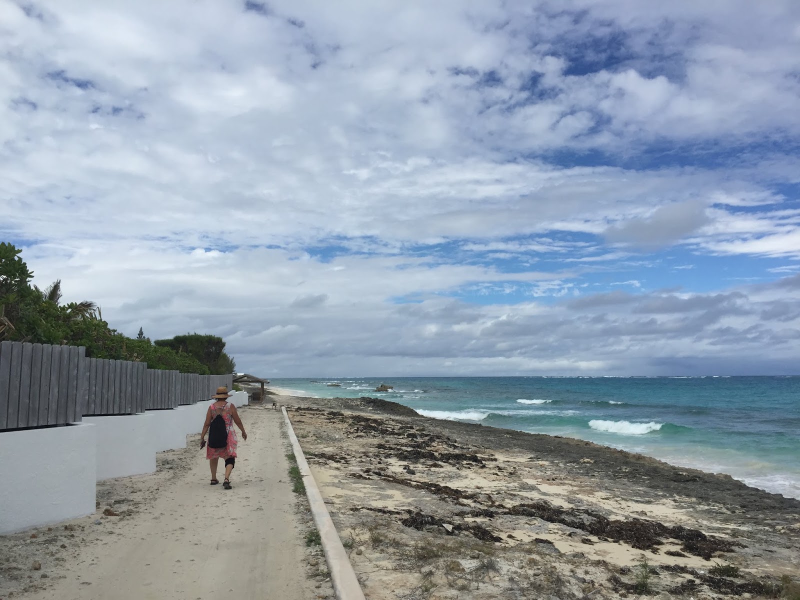
The next day was clear, and we hiked out to a spot on the north end of the island called "The Low Place".  There, the island narrows to a low strip of rock barely a hundred feet wide.  At high tide, the waves on the Atlantic side wash right over it!   On the way there, we noted that the properties were larger and more "high end", but still maintained a Bahamian flavor instead of being imported "McMansions".
Road to the North End
Beautiful Properties Along the Way
Atlantic Coast Approaching The Low Place
Almost There
The Low Place
We got there at low tide, so the water wasn't  coming over.  But we could see fresh seaweed caught on the floorboards of the little covered pavilion there.  The two coasts are so different; the Atlantic side rough and rocky, and the Sea of Abaco side placid, sandy,  and turquoise.  Joan went wading.
Wading on the Beach
After we walked back to town, we treated ourselves to dinner out at the Hibiscus Cafe, which had been recommended, and was delicious.
Hibiscus Cafe
Our stay in Man O War continued to be extremely enjoyable.  We met a couple of Canadian cruisers named Dan and Paula aboard the S/V Erin Kjarr that was moored close to Dolce Vita.  We ended up traveling with them for the next several islands. 

On our 6th and final day in MOW, we got up a little early and went to breakfast at the Museum, Coffee Shop, and Visitor's Center.

Museum, Coffee Shop, and Visitors Center.
Two women operate the shop out of a modern addition to one of the oldest houses on the island.  They have collected photos, artifacts, and memorabilia from all of the families living on the island, and have preserved it all in a nice little museum in the old building.
Afterwards, we walked by Edwin's Boatyard #2 and watched three workers laying up a fiberglass panel for a boat.  They worked with economy of motion and precision, clearly an experienced team. One cut and placed the fiberglass cloth, and the others wetted it out with resin and took care of dressing the edges.  None had fume masks on, and only the fiberglass cutter had a dust mask on!  Clearly no OSHA here!


Tomorrow, we will head South to Hopetown, on Elbow Cay, for our next Island adventure.  For convenience, we will try to get a mooring in the harbor there, but we are told that the mooring field is very busy and always full.  But we'll try, and if we can't get one, we'll anchor just outside of the harbor (there's no room to anchor inside) and dinghy in.

Life is good.

Tuesday, March 12, 2019

Marsh Harbor

1748 nm   N26 32.855  W077 03.391

Once anchored at Marsh Harbour, we dinghyed ashore for a quick look-around before the sun set. 

One of the first things we encountered was a humorous trash-can holder modeled to look like the cartoon Great White Shark "Sherman" in the comic strip "Sherman's Lagoon".
We ended up at "Snappa's" for drinks.

On Thursday, our crewmember Bill left us again to catch a flight home.  When we came ashore, there was a regular traffic jam at the dinghy dock!  This was the result of a call for volunteers on the morning's Cruiser's Net on the VHF radio, asking for help cleaning up the trash on the road to Maxwell's, which is the largest grocery in Marsh Harbour.
Traffic Jam!
Waiting for the Taxi
Good-bye Bill. We'll Miss You!
We later joined the volunteers picking up trash.  They collected over two pickup trucks worth of trash!
Cleaning the Road to Maxwell's
Afterwards, lunches of cracked conch and shrimp at Wally's Restaurant.   This is a hi-end boutique & restaurant, aimed squarely at the tourist trade, but we treated ourselves.
Classy Setting
Ornate Landscaping
Cracked Conch
Skewered Shrimp
Over the next several days, we walked all over Marsh Harbour.  It has three (!) well stocked hardware stores, a number of marine stores, and quite a few restaurants, both touristy and local. And Maxwell's grocery is the equal of any big grocery in the U.S.  But overall we felt a bit disappointed. Its a great place to reprovision, but other than eating out, there didn't seem to be much else to do.  Lots of cars, people, and trash.  Felt more like being in a poor town in the US than in the Bahamas.  We were told that the crime level here was high, but we never saw any overt sign of it. NOT like things were at Nassau two years ago!  (We later discovered that our credit card number had been stolen while we were here, and had almost $6000 in bogus charges against it before we discovered it and cancelled the card!)

Sigh.

So, after five days here, the refrigerator was full, the engine was gassed up, and we were ready to move on and really discover the Abacos.  Another front was due in a couple of days, so we wanted to try and get a mooring ball in Man O War Cay harbour. Its small and protected on all sides, so its a good place to ride out a blow.  By good fortune, our cruising friends Ron and Phoebe aboard S/V Jibay Na Noodin were in Man O War.  We met them two years ago in the Exumas, and we hoped to be able to get together with them at MOW before they left.

Life is good.


Monday, March 11, 2019

To The Abacos!

1674 NM   N26 01.054  W077 24.527

Today, we left Great Harbor Cay headed for the Abacos.  For the first time since we arrived in the Bahamas, we were headed for someplace new, a place we hadn't visited before!

Our ultimate destination was Marsh Harbour, but that is too long a trip to make in one day.  We had planned to break it up into three legs.  First, a 40 mile hop to the southwestern end of Great Abaco Island.  This would get us across the deep water of the Providence channel.  We had picked this specific day for crossing because the seastate was mild.  We would anchor off of a penisula called Sandy Point, and the next day travel around "Hole-In-The-Wall" at the south end of Great Abaco, go north in the deep water off of the island, and enter the relatively shallow Sea of Abaco at the Little Harbour Inlet, anchoring just inside behind Lynard Cay.  And the third day we would go 28 miles up the Sea of Abaco to anchor inside the protected anchorage at Marsh Harbour.

But even before before we got started, this plan had to change. (Anybody notice a recurring theme here?)  The inlet at Little Harbour is shallow, narrow and bordered by reefs.  If the tide and the wind are opposed, it can be dangerously rough, so I had to plan our travel times so that we would arrive there at slack tide, which happened to be around 12 noon.  And working backward from that time meant that we would have to leave our anchorage at Sandy Point around 1 AM!!  But, time and tide wait for no man,  so once again, our plans included an overnight passage with overlapping watches.

When leaving Great Harbour Cay, you first have to go West, and then North, to go around the Island.  The South side is too shallow for this.  On the North end, two different cruise ship companies have purchased two different islands (Big Stirrup Cay and Little Stirrup Cay) and transformed them into exclusive private resort playgrounds.  The cruise ships anchor out and ferry people ashore.  One of the lines is even constructing a huge dock and a waterpark there!
Cruise Ship At Anchor
Waterpark Under Construction
Once past, we were well out onto the Providence Channel.  The water is thousands of feet deep, and can get quite rough when the weather is unsettled.  Fortunately, we had chosen our weather window well, and our only concern was to keep track of the numerous freighters going through the channel.
One of Many Freighters
In no time at all, we were anchored off of Sandy Point,  A squall passed to the East of us, dumping rain that missed us, but treated us to a small rainbow afterwards,  and helped with a spectacular sunset.
Rain to the East
And a Faint Rainbow Afterwards
This Never Gets Old
At Midnight, we got up, had a light snack, and got underway by 1am.  Joan and I took the first watch.  At 4 am, Bill came on and I went off.  At 7am Joan went off and I came on, just in time for the dawn.  The wind had completely died, and there were just large smooth swells slowly coming in from the deep water to the East. 
Deep Water Dawn, East of Great Abaco

The entrance into the Sea of Abaco at Little Harbour looked intimidating, with the swells turning into breaking waves as they encountered the reefs on either side of the inlet.  But the inlet itself was basically calm, and we came right through the center of it without trouble. Tide timing works!  But its nerve wracking to see breaking waves that close on either side of the boat.

Once on the Sea of Abaco, the shallow waters and bright sunlight produced that amazing turquoise color that the Bahamas is so famous for.  The Sea of Abaco is somewhat reminiscent of the Chesapeake Bay in size, but that blue water makes it fantastically picturesque.
Motorsailing on the Sea of Abaco

At this point, our plan was to anchor behind Lynard Cay, and continue up to Marsh tomorrow.  But our tide timing had gotten us here so early that we decided to just continue on all the way to Marsh Harbour, only another 28 miles.  There was a westerly front forecasted to move through tomorrow evening, and I felt better if we got safely tucked away sooner rather than later.  You never know when a breakdown is going to delay you!

We motorsailed on the jib for a bit, but eventually had to take it down as the wind came too far forward.  The rest of the trip was uneventful, except for part where we had just rounded Matt Lowe's Cay to head in to Marsh Harbour.  A squall sprang up so suddenly that before I could even get a jacket, I was soaked!  And that water is COLD!  Visibility dropped to a boat length while the skies opened up.

But it was quickly over, and the sun started drying everything off.

The approach into Marsh Harbour is convoluted.  You basically have to go in a large spiral, rounding the peninsula first on the south, then on the North, then turning into the entrance channel, then turning into the anchorage.  Its enough to make you dizzy.

The large anchorage had a lot of boats in it, but they were well spaced, and there was room for more.  We found a nice shallow spot that wasn't too far from the dinghy dock, and dropped the hook, which bit in and set immediately.

End-of-Voyage drinks all around.

Life is good.


Tuesday, March 5, 2019

Great Harbour Cay

1633 NM   N25 44.809  W077 51.500

It would seem that one of the nice things about getting into a new port in the morning is that you have the rest of the day left to explore!  Alas, this "extra day" is an illusion,  as you're usually so tired from the overnight passage that you end up sitting around and napping all afternoon!

Still, we managed to do something!

Great harbour Cay Marina tries very hard to facilitate regular activities for the boaters every week.  And today, Tuesday, it was a sunset "Dinghy Drift" out in the harbor.  It was being organized by Jeff & Karen Siegal, the founders of Active Captain!  They had their home, the large motor vessel "Red Head", docked at Great Harbour Cay for a while.  

So, we lifted our dinghy off of the foredeck, launched it, and lowered the outboard onto it.

The dinghy drift was fun and chaotic, as they brought their three (!) dogs with them in the dinghy.  Karen had her hands full trying to keep one dog from climbing into every other dinghy, while preventing a second one from begging snacks and beer!
Jeff
Karen
Blowing Sunset on a Conch Shell Horn
We stayed in Great Harbour a total of 6 days.  Joan scored a couple of large lobster tails from a fisherman one day, and we had them on the grill that evening.  They were big enough to feed the three of us and we were stuffed!  We also had fresh Hogfish another time. 

During the next day, Joan and Bill had fresh conch salad, prepared right there in the dock from live conch.  Doesn't get any fresher than that! 

We wanted to do some exploring farther afield than we could walk, so we tried to rent a golf cart.  If you recall our previous trip here, the cart we got was so badly rusted that it was flexing in the middle, as if it were about to snap in half!  We actually saw that same cart, pushed into the weeds with a "For Sale" sign on it!

Turns out, there's only one guy on the whole island who rents carts, and he only has two left.  One was already rented out for an extended period, and the other had its engine disassembled for repairs!  But it turns out he also rents "Jeeps".   What we got was a rusty Suzuki Sidekick.  Some of you may remember this as the model that Consumer Reports gave a "Not Acceptable" rating due to its tendency to roll over during high speed turns!
"Suicide" Suzuki
But wait, there's more!  Inside, the door release on the passenger side was hanging by the linkage with a broken hinge.  On the driver side, the handle was gone completely, replaced with a stiff piece of twisted aluminum wire that you had to pull on to open the door!

Quaint. But so Bahamian.

But, it got us around, and sure beat walking.  We followed the main road all the way to the northern end of the island, a place we haden't gotten to on our last time here.  It seems that all the high-dollar real estate is up there.  Saw a really puzzling "tree"(?) that looked like nothing so much as a 30 ft tall stalk of broccoli!
Eventually, the paved road gave way to an unpaved track that led off into the undergrowth, getting narrower and narrower.
I hope we can turn around somewhere!
A quick check with Google Maps (yes, even here) showed that we were headed to someplace labeled "El Panos Glicko".   A google search of this turned up only one entry, describing this a simply "a Bahamian ghost town"!

The trail ended in a loop, so turning around was no problem.  But there was no sign of any sort of construction here at all.  We spotted a trail leading off into the woods and followed it.
 
Trailblazer Joan
It popped out onto a small beach on the Banks side of the island, looking out towards Great Strrup and Little Strrup Cays.

It was an exotic looking place, with the rocks carved into fantastic shapes.
 
Back on the trail loop, we saw a blue ribbon hanging from a branch, and discovered that it marked another trail head. 
Another Trail Head.  To where??
We followed this one, and it led to the shoreline on the deepwater side, the Providence Channel.
The character of the shore was completely different here, with no sand, high rocks, and crashing waves.  A bit intimidating. And we would be crossing this channel soon!
Rocky Shoreline
Crashing Waves
We never did find any trace of "El Panos Glicko".  A true ghost town!

Back in the jeep, headed for the other end of the island, we wanted to get to the shelling beach there just before low tide.  We were a little late, and got there right at low tide, so the water soon started rising. 

But, what a place!  The sandbar goes out a half a mile!
That Little Speck Way Out There Is Joan!
The pure white sand beach goes on for 5 miles, and is all but deserted.

There are shells, starfish, sea urhins, and hundreds of sand dollars, both live and dead.
This is How a Live Sand Dollar Looks in the Sand
Or Sometimes Like This
Rinsed Off, They're Dark Brown, Not White Like the Dead Ones
Something Got Part of this Starfish
Once the warer started getting ankle deep, we called it quits and headed back to the Marina.

In the Evening, the three of us took the Jeep over to Coolie Mae's resturant, overlooking the western shore, and known for its sunsets.  Unfortunately, it turned overcast and rained, so no sunset :( .  But dinner was great and well worth the trip.

Tomorrow, we would return the jeep, and begin preparations for crossing the deep and often treacherous waters of the Providence Channel, on our way to the Abacos for the first time!

Life is good.