Monday, November 26, 2018

Harbortown at Ft. Pierce

1089 nm   N27 28.084  W080 19.728

Another catch-up post that is being written well after the fact.

While we were in Vero, I had called and checked if Harbortown could take us early, since we were about 5 days ahead of our Dec 1 reservation.  They said "Sure, no problem!"  so,  come Monday morning, off we went.

Its only a short trip from Vero Beach to Fr. Pierce,  less than 15 nm, so we were there in no time.  We first pulled into the fuel dock to top-off tanks, and get a look at the slip before entering it, as thay had told me it was at the end of the fairway and narrow.

And they weren't kidding! it was nestled right up against the mangrove buffer along the shoreline, and the large powerboat in the next slip hung out past the outer pilings.  The short finger dock would require backing in, but I was in luck as I would need to back to Port, and our boat has a strong propwalk to port while in reverse.

And it all went according to plan without a hitch!  I was so glad that our difficult slip at home had given us so much practice at backing into a tight slip!

And once we were in and tying up, a large, graceful manatee surfaced near our stern!  He ignored us and proceeded to work his way past us, munching on algae and bits of mangrove along the shoreline.  We managed to get a few photos as he worked by the bow.
Manatee!
Snug in our Slip for the Next Month
At this point in our trip, we are going to shut down the boat, and leave it here for a month as we fly home for Christmas with family.  We will return after Christmas, and resume our travels in January!

Life is good.

Friday, November 23, 2018

Vero Beach

1076 nm   N27 39.432  W080 22.202

First off, appologies for the lateness of the next few posts.  Although they're dated according to when we were at those spots,  I never got around to writing them before we left for our Christmas interlude back home, so I'm actually writing this after New Years.

Any way, once we left our anchorage behind the spoil island at Malabar, it was a short 22 nm run down to Vero Beach.  We planned to stop there for 3 days to visit with our friends Vic and Marilyn of S/V Whisper, who were renting a condo there while their boat was on the hard for bottom work.

Vero's Municipal Marina is known for its extensive and sheltered mooring field, but I' not comfortable with their policy of rafting up to 3 boats on a single mooring, so we took a slip.  They put us on a face dock off the end of a T-head, so it was a real simple docking.

The boater's lounge and the bathhouse are clean and well maintained, and there is a bus stop for the extensive network of free bus lines that cover both the beach and mainland portions of the city.

Unfortunately for us (our timing always seems to be bad) the buses stop early on Sat and don't run at all on Sunday, and we were there across a weekend!

Vic and Marilyn have their car here, so they picked us up and Drove us on some errands.  This included a stop at Marine Connections, a surplus and salvage liquidator.  This place is enormous!  Acres of grounds with tons of stainless arches, pulpits, fuel tanks, bins of Starboard pieces, and two large wharehouse-sized indoor spaces.  The first one has mostly enormous quantities of small bits from salvages, while the second one appears to be stock and inventory purchased from bankrupt companies and fabricators.   You could spend days at this place and not even begin to scratch the surface!  To give you an idea of the size, all of Bacon's in Annapolis woud fit in one isle of this place! I only wish we lived within driving distance!

Afterwards, we had lunch out, and did a little grocery shopping and Liquor resupply.

The next day, we kicked back and relaxed, doing a lot of reading.  In the evening, we walked over to Riverside Cafe for dinner.  We sat on the open deck overlooking the Indian River.  The resturant has a dock, and they've arranged a number of green underwater lights right next to the deck.  The fish (Snook and Catfish) congregate there, swimming against the current and waiting for handouts.  The resturant has even installed a little quarter-operated dispenser for fish food!  Crackers and bits of dinner rolls also worked well.  The water would literally explode every time a handfull of crumbs was tossed in!  Great entertainment.

Fish!
We made dinner out of appetizers, Joan having Mussels and me having steamed spiced shrimp.

The next day, I got a hold of Harbortown marina in Fort Pierce.  Even though we were scheduled to not be there until the first of December, they said they could accomodate us early.  So, Monday, we will head out and make the short trip to Ft. Pierce., where we will leave the boat while we fly home for Christmas with family.

Life is good.

Thursday, November 22, 2018

Thanksgiving at Malabar

1052 nm   N27 59.331   W080 32.775

Although today was Thanksgiving, we had no special plans or destination.  Our goal was a 41 nm day which would put us near the relatively unknown town of Malabar, just south of Melbourne.

Along the way, we once again got a look at the NASA Vehicle Assembly Building (VAB) in the distance, although the view was a bit hazy compared to our last trip.
VAB in the Distance
The VAB, which was completed in 1966, was originally built to allow for the vertical assembly of the Saturn V rocket for the Apollo program and originally referred to as the Vertical Assembly Building. In anticipation of post-Saturn projects such as the Space Shuttle program, it was renamed to the Vehicle Assembly Building in 1965.

Nearby are the launch pads, including pad 39A which launched the moon missions, and is now used by SpaceX for Falcon 9 launches.  Unfortunately, the haze made them hard to see.

Our timing  was just a bit off.  SpaceX had just had a launch the week before we got here.  It would have been awesome to have been able to watch that from the boat!

The rest of the day was pretty uneventful.  We arrived at our chosen anchorage just past 2 in the afternoon,  a semi-sheltered spot behind a spoil island near ICW mile-marker 925.

I know, you're going to ask "What the h*#l is a spoil island?"

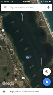
Well, most of the ICW had to be dredged in order to make it deep enough for boats.  Down here, the Indian River is wide but very shallow.  It wouldn't have been practical or economical to haul the dredge tailings ashore, so they just piled them up in the river next to the channel they were dredging.  When the pile got too high,  they moved to a new location and started again.  This resulted in a "dotted line" of islands that parallel the ICW channel.
Spoil Islands West of the ICW Channel
Currents have steadily eroded them, creating a series of sandbars that extend to the SouthWest of each one, causing them to resemble a series of commas in the satellite view of the area.

The Florida Department of Environmental Protection created the Spoil Island Project, which has turned these Islands into recreation areas or protected bird nesting grounds.  This particular one is a recreation area, and has 8 feet of water behind it, ideal for anchoring.  The island itself provides protection from waves and wakes from the East.  It was calm when we got here, but the wind was due to come around to the North later tonight, which promised a little bumpiness.

Once we were settled in, Joanie went into high gear preparing a Thanksgiving feed, complete with a Turkey Casserole, Cranberry sauce, and all the trimmings.
Thanksgiving Dinner
We ate very well.

Life is good.


Wednesday, November 21, 2018

Titusville

1011 nm   N28 37.337  W080 48.135

Today's plan was 42 nm to Titusville.  We would need to stop at the Titusville marina for fuel and a pumpout before finding an anchorage.

Another early start, on our way by 6:45am.  We actually beat Pearl this time!  But no matter.  They soon overtook and passed us.

The current and wind was again in our favor, and we did 6 knots or better the whole way.  We got in so early, that we could have continued on as far as Cocoa if we had wanted.    Then things got "interesting" as we went into Titusville Marina.

The fuel dock and pumpout were located on two different T-heads, so that meant docking the boat twice.  But what was really bad was that the fuel dock was partially exposed to their inlet, and the pumpout dock was fully exposed, and the 14 knot north wind was driving large chop with whitecaps almost directly into the inlet!

The dock had no rubber fendering, and I could see from the abraded condition of the pilings that this wind was not an unusual occurrence.  We got onto the fuel dock without incident, but had to quickly force one of our fenders between us and the piling.  It was crushed almost flat, but it held.

Once fueled, we had a difficult time getting off the dock.  The wind was keeping us pinned to it.  Several dockhands kept fending our bow off as I tried to power away, but our port stern kept rubbing the dock, threatening to bend the frame holding the solar panels and windgen.  I managed to fend off enough to avoid damage, but that left me with another dilemma.  In order to keep the stern off the dock until we were clear of it, I had to turn hard to port to make the stern swing out.  This worked, but left us aimed directly at the boat docked on the inside of the next T-head!  As soon as my stern was clear, I turned hard to starboard and gave it full throttle.  This scooted our stern around and took us clear of the next T-head, where we needed to do the whole process over to get a pumpout!

( I later learned the the boat we had been aimed at was S/V Our Log,  whom we had met in Bimini 2 years ago, and had been playing leapfrog with on this trip!)

It took two passes to safely get on the pumpout dock, and the conditions were even worse.  After the pumpout, I had a discussion with the dockmaster.  We decided the best bet would be to back off of the T-head, and use a cleated-off stern line with the engine in reverse.  This would spin us around the outer piling until out bow was directly into the wind, allowing us to power forward cleanly.

And it worked like a charm!  Fairly slow and completely controlled.  As soon as we were bow to the wind, I signaled him and put it in forward.  He uncleated the line and tossed it aboard so we wouldn't wrap it on our prop.  His timing was flawless.  He really knows his stuff!  

And away we went.  I had to give it a lot of throttle to initially overcome the wind and chop, but once we were moving, everything was fine.

Note to future self:  Never use Titusville Marina when the wind is from the North!!

Our next challenge was choice of anchorage.  Normally, I would have backtracked 1 mile North to the NASA railway bridge, and anchored in the lee of the causeway on the SW side.  This would be well protected from North winds, and is an excellent spot we have used twice before.    But Titusville is where we would part ways with Pearl,  as they needed to make arrangements to be hauled so they could complete some bottom work.   So they were anchored just south of the mooring field and within an easy dinghy ride in.  That location is completely exposed to the North, and would be a bumpy overnight.  But we wanted to have them over for one last round of sundowners, so that's where we anchored.

The sunset was great, and we had Dark & Stormys all around.
Sunset Over Titusville
Another milestone! Today we passed the 1000 nm mark!

Life is good.

Tuesday, November 20, 2018

Daytona

969 nm   N29 12.007   W081 00.410

Back to our usual routine, up early and on the way by 7am.    Pearl got a head start on us and was already a mile down the river.  Today's plan was 47 nm to Daytona, where we would anchor.  The current was in our favor, and there were no trouble spots along the way, so it promised to be an uneventful day.

We got in around 2:30pm with plenty of daylight left.  As usual, Pearl was already at anchor and settled in.  We threaded through a mix of transient and "local" boats, all at anchor, and dropped the hook close to Pearl and a little bit inshore of them.    A sailboat only 4 or 5 boat lengths inshore of us was hard aground and heeled over 10 degrees.  A bit intimidating,  but the tide here is almost non-existent, less than a foot.  A blessed relief after the 9 foot tides of Georgia!!  We were in 8 ft of water and it would only increase to 9.  Perfect!

Life is good.

Saturday, November 17, 2018

St. Augustine, 3 Days

922 nm   N29 53.516   W081 18.566

Warning. Long post, covers 3 days.

Since its only a short 12 NM from Pine Island to St. Augustine,  we were able to sleep a little later this morning and left about 8am.   The trip was quick and easy.  Even crossing the inlet was calm.  In no time we were passing the San Marcos fort and approaching the Bridge of Lions.
Castillo de San Marcos
After we radioed in, we tied up up at their fuel dock to top off our tank, and then transferred to our slip.
On the Dock at St. Augustine
We initially paid for two nights, but later decided to extend it to 3 nights.  St. Augustine is one of our favorite stops on the ICW.  The marina is right in the middle of town, and everything is within walking distance.  A friend of ours once stopped here for overnight, and ended up staying 4 months!

Pearl took a mooring ball for 3 days, with the possibility of staying longer if there was room.  Once everybody was settled in, they dinghyed ashore and we set out walking. 

Our first two stops were to be the "Booze Tour", successive tours of the San Sebastian Winery (free samples!)  followed by the St. Augustine Distillery (more free samples!).  Both were quite generous in their samples,  and we were glad we were walking, not driving, afterwards!
Upstairs Catwalk as San Sebastian
One of the Tasting Rooms
The winery tour was self guided, with multiple tasting stops for a total of about ten different wines.  The Distillery tour was led by a "Spirit Guide", who gave us a presentation on the history of the distillery, which was built in a preserved 1907 Ice House, followed by tours and explainations of the stills and the aging rooms.  Although their focus is Bourbon, they also do Gin, Rum,  and Vodka. all in small batches.  The sampling bars went through a number of mixers (Old Fashoned, Florida Mule, etc) followed by a trip upstairs to the "neat" bar for shots of any and all of their spirits.
A thoroughly enjoyable afternoon!
Stills
Aging Room
Afterwards, we hiked over to St. George Street.  This has been closed to car traffic and turned into a pedestrian walkway that goes on for about half a mile.  It's very tourist trappy, but still a lot of fun to walk and people-watch.  We stopped for lunch at a place that is reputed to have the best pizza in the country, and the line out the door seemed to agree.  A nearby pizza place across the street was virtually empty. I thought the pizza was good, but not particularly outstanding.  Superior marketing, I guess.

By blind luck, and for the second time, our stay here coincided with the lighting ceremony for the "Festival of Lights".  The downtown park has over 1 million lights strung through the trees, bushes and palms, and they have a big party with live music, and a countdown to light it all up at once.  The city is already lit up with white lights outlining most of the buildings, and this just puts it over the top,
Before the lighting, on the recommendation of a local, we hiked out to the center of the Bridge of Lions to get a view of the city from higher up.
View from the Bridge of Lions
...three, two, one, ... Lights!

The next day, we hiked around, enjoying the waterfront views and getting a few errands done.
North of the Bridge
Panorama of the North Mooring Field
I'm always interested in the specifics of the architecture of these old towns.  One of the things I learned here is that there is no clay to make bricks, so early spanish settlers used someting called "tabby".  Tabby is a type of concrete made by burning oyster shells to create lime, then mixing it with water, sand, ash and broken shells.  Tabby was used like concrete for floors, foundations, columns, roofs or was made into bricks.  When used for buildings, its often coated with white stucco.  A naturally occuring version of this, a sedementary rock called Coquina, was mined in blocks and used to construct the San Marcos fort.
A Tabby Wall on St. George Street
Joan had discovered that an old friend of hers from Laurel was now living in St. Augustine and was just ten minutes from downtown.  We arranged to meet them for happy hour & dinner at a nearby brewpub called A1A Ale Works.  The food and company were both great.
Joan, Terry, and her husband Ed
On our last day in St. Augustine, we got together with Bruce & Gayleen in the morning.  Since no trip to St Augustine is complete without a visit to the Sailor's Exchange, we split up, with the men going to gawk at boat hardware and the women off to various thrift stores.
Sailor's Exchange
Used Boat Bits
It reminded me of a larger version of Bacon's in Annapolis.

After we reuinted with the women, we did a short tour of the outer grounds of Flager College.  The centerpiece of the campus is the former Ponce de León Hotel, a luxury hotel built in 1888.


In the late afternoon, we briefly met up with Sean and Eva from S/V Emerald Fire, now tied to a mooring.  We invited them to join us for happy hour, but they politely declined, saying thay had patried a lot the night before, and were going to turn in early tonight.

We ended up returning to A1A Ale Works with Bruce and Gayleen.  They had been unable to extend their mooring for even one more night, so they would be moving on in the morning too.  We spent another pleasant evening relaxing with good food and good friends.

Life is really good.


Friday, November 16, 2018

Past Fernandina to Pine Island

910 nm   N30 03.106   W081 21.878

Today's travel would take us past Fernandina Beach, FL.  We had originally planned to stay a day or two at Fernandina, but when we called, the marina was still limping along from damages from hurricane Matthew, 2 years ago!  No fuel, no pumpout, and no face dock.  Just a few slips inside the T-head, and those were shoaled to 4 ft!  They finally just got their funding, and are closing next week to begin the restoration.  So, once again, no visit to Fernandina Beach.

And Matthew and his siblings have left another legacy.  The channel near Fernandina has become shoaled to unpassable depths in some places, with the deeper water now having moved completely off the charted channel!  Fortunately, there is a solution.  A well-known boater who goes by the online name of bob423, posts daily tracks of his ICW travels, and had just passed through about a week before us.  I don't know what kind of sonar capability he has,  but it must be sophisticated (side scan?) since he confidently states that his track will follow the deepest water through.  And Bruce, aboard s/v Pearl, has downloaded these tracks into his chartplotter and follows them.  Although our chartplotter has this capability too, it requires transferring the downloaded tracks onto an SD card, and we didn't have one aboard.

So we stuck close on Pearl's stern as we gingerly passed through the skinny parts.  It's unnerving when your chartplotter shows that the path you're taking goes over dry land (!!), but bob423 always found the good water.  Bruce commented that a lot of people owe that man a dinner and a good bottle of whisky! I couldn't agree more!
Pearl Leading the Way Through

Once past the shallow parts, the trip became pretty easy.  Pearl resumed their normal cruising speed, which is a little faster than ours, and slowly but steadily pulled ahead.  There was one confusing part crossing through the St. Johns River, where the channel markers have been moved radically off of the channel shown on the charts.  But reality always trumps charts!  The depth sounder is King, followed by the channel markers, and then the charts.  Once we started following the repositioned markers, the depths were fine.

Our planned destination today was Pine Island, a popular anchorage about 50 nm from our starting point at Cumberland Island.  We got there just before 4pm, and Pearl was already anchored.  Our first anchor attempt seemed to go well, but when I backed down on the anchor to set it, it kept slowly dragging backwards.  Eventually, we moved so far that we were in 8 ft of water, and the tide still had 4 ft to go down.  We would be aground at low tide!

So we retrieved the anchor and tried again at another spot a little closer to Pearl.  This time the anchor set with no problem.

Before sunset, three more sailboats pulled in and anchored.  This is a popular spot!

After our usual end-of-voyage drink, we had a hot supper,  did some reading, and retired early.  Tomorrow, we will reach St. Augustine, where we have a slip reserved for a couple of days to make exploring the town easier.

Life is good.

Wednesday, November 14, 2018

Cumberland Island

859 nm   N30 46.432  W081 28.234

Although the trip from Jekyll to Cumberland would be short, we got up early and were on our way by 7 am.  The idea was to get to Cumberland Island early enough to go ashore with Bruce and Gayleen and hike some of the trails.

But the day dawned cold and overcast, and did not improve.  We got to Cumberland and anchored just north of s/v Pearl.  The wind was brisk and out of the north, allowing a lot of chop to build up in the anchorage.  And it was drizzling.  It looked like it would be a cold, wet dinghy ride in and back out, and with no sun to warm us, we all four decided to hold off until tomorrow, when the weather was supposed to improve.

The next day proved to be much better.  The wind swung around to the NW and reduced quite a lot, causing the chop to die down, and there was partial sun and no rain.

Meanwhile, our daughter texted us that it was snowing back home!

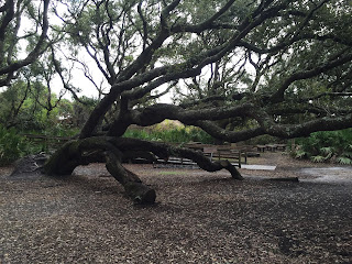
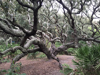
We dressed warmly and went ashore.  Cumberland Island has some of the most spetacular southern coastal foliage I have ever seen!  The Live Oaks alone are magnificent, growing to huge twisted sizes and dripping with Spanish Moss.

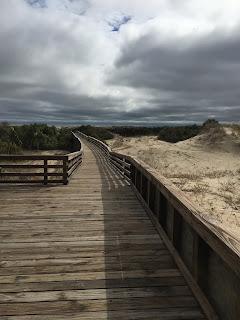
A long boardwalk led over the dunes to the beach on the ocean side.
Next, we hiked south on the island to visit the ruins of the Carnegie Mansion.  Owned by Thomas Carnegie, brother of Andrew Carnegie, this gigantic structure and the surrounding grounds was modelled on an Italian villa, and was named Dungeness.  The Carnegies moved out of Dungeness in 1925. In 1959 the Dungeness mansion was destroyed by fire. The ruins are today preserved by the National Park Service as part of Cumberland Island National Seashore. They were acquired by the Park Service in 1972.
The surounding fields were used for Polo matches, and some 150 wild horses still live on the island.
We hiked back to the dinghy dock, and rode out to Dolce Vita, where we all had sundowners and snacks, and watched another impressive sunset.
Life is good.


Monday, November 12, 2018

Jekyll Island

833 nm   N31 02.737  W081 25.364

Our destination today was Jekyll Island.  But to get there, we would first have to go through the notorious Little Mud River, reputed to be the worst spot on the Atlantic ICW.
We left anchor a little later than usual at 8 am in order to hit Little Mud on a mid rising tide, and this worked like a charm.  We never saw anything to worry about, although there were a couple of spots that would have been less than 4 ft at low tide!

Once past Little Mud, most of the trip would be wide, deep river, until we got to Jekyll Creek, running along the western shore of Jekyll Island.  Reports were that there was no water at low tide in parts of Jekyll Creek.  Unfortunately, the timing for Little Mud meant that we would be getting to Jekyll Creek just at or past high tide.  This was both good and bad.  Good because it would give us maximum water, and bad because if I strayed from the channel and ran aground, it would be 12 hours before we would have a chance to get off!  Needless to say, I was very cautious when we got to Jekyll Creek!

And it was true, there were spots that would have been impossible to get past at low tide, but we stayed in the deeper water and made it through to the Jekyll Harbor Marina.  A sign outside the marina office welcomed us by name.
Welcome Sign

We like Jekyll Island, and planned to stay here for two days.  The marina has loaner bikes and now will sign out an electric golf cart for 90 minutes at a time.  We took advantage of this.
Our Chariot

 The tree-lined streets are like something out of a book, and the Mansions are spetacular.  Now a tourist destination, Jekyll Island was the winter retreat for some of the wealthiest families in the late nineteenth and early twentieth centuries.  In 1886, the Jekyll Island Club was formed by 53 members, with a limit of 100 members to preserve the club's exclusivity.  The clubhouse still stands as a hotel and restuarant.

The Jekyll Island Clubhouse
Bruce and Gayleen were now just a day behind us, and would leapfrog past us tomorrow and anchor at Cumberland Island, where we would meet up with them the next day.

Life is good.